Articles
- BJCMNP Management Programmes
- Natural Heritage Conservation Programme
- Cultural Heritage Preservation Programme
- Enforcement and Compliance Programme
- Education and Public Involvement Programme
- Recreation and Tourism Programme
- Monitoring and Evaluation Programme
- Governance and Administration Programme
- All Pages
Enforcement and Compliance Programme
| Programme Goal To stop encroachment of the BJCMNP boundary and destruction of the forest and wildlife within | |
|---|---|
| Objective 1 | To increase the level of presence of enforcement officers and their effectiveness in detecting and mitigating breaches of relevant legislation |
| Objective 2 | To contribute to the resolution of breaches inclusive prosecution of offenders |
| Objective 3 | To resolve boundary discrepancies and re-establish and mark all boundaries. |
| Objective 4 | To raise community awareness regarding: the BJCMNP boundary and legislation, particular issues that threaten the BJCMNP, and increase community involvement in addressing these issues. |
Between 2005 and 2009, the number of National Park Ranger patrols doubled:
| Year | Number of Patrols |
|---|---|
| 2005 | 43 |
| 2006 | 80 |
| 2007 | 120 |
| 2008 | 175 |
| 2009 | 100 |
Unfortunately, due to funding and other challenges e.g. resignation of staff to move on to other positions, the numbers of patrols began to decline again. During the current Management Plan period efforts are being made to increase the number of patrols and to stabilize the programme. This is important as during the period of increased patrols, there was clearly a decline in illegal activity. The current Management Plan recommends between 12 – 15 Park Rangers based on international studies conducted by Bruner et. al. (2001).
The National Park Regulations of 1993, section 32, state the functions of a National Park Ranger as, “to patrol the area of each national park, to protect the resources of that national park and without prejudice to the generality of the foregoing, to-
- patrol and monitor the various zones of the national park;
- enforce these Regulations;
- maintain patrol vehicles, marking facilities and trails;
- provide first-aid, emergency or rescue assistance to national park users in the event of accident or injury; and
- assist in the conduct of environmental monitoring programmes”.
This is exactly what the BJCMNP Rangers do – they are involved in all aspects of National Park management, including encouraging compliance through interpretive enforcement.
In 2005, the Rangers began to use GPS units to map their exact location on patrol using geographical information that could be uploaded on to maps of the National Park once the Rangers returned to headquarters. They also take photographs and notes of their observations. This information is used to guide the Enforcement and Compliance Programme in regard to further action to reduce breaches of legislation.
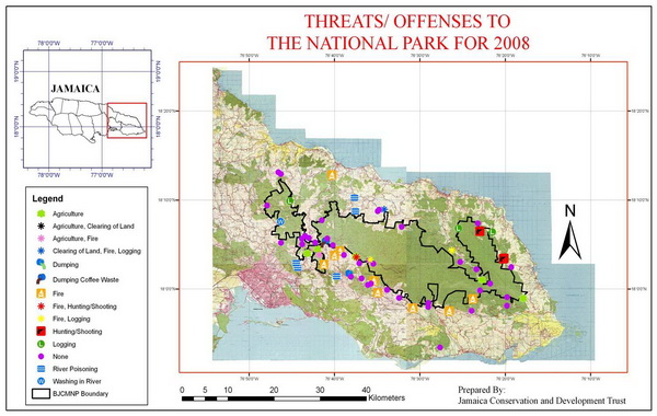
Map showing threats and/or illegal activities in and around the National Park boundary, observed by Park Rangers on patrol during 2008
Illegal activities and threats to the National Park’s ecosystems are reported to the relevant government agency (National Environment and Planning Agency and/or Forestry Department) and action taken accordingly.
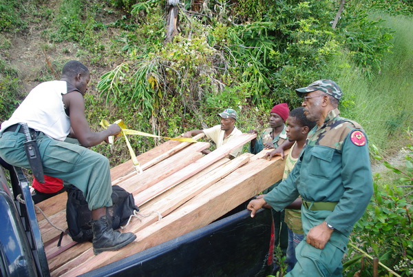
Confiscation of Juniper Cedar stolen from within the National Park